|
|
| |
Global Partners
Exclusive Representative Contract
with Global Companies |
|
|
|
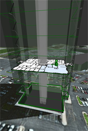
실내 위치(측위) 추적 시스템 > Product Overall |
| |
| NEON 3D Indoor Location |
| NEON® delivers mapping and location indoors, underground, and in dense urban areas where GPS is unavailable or unreliable. NEON uses advanced sensor fusion, ranging, and mapping algorithms to deliver precise, real time location even in areas without GPS or mapped Wi-Fi. Uniquely, NEON delivers indoor location without requiring pre-existing or networked infrastructure. |
|
 |
Real-time Location:
Real-time 2D and 3D location indoors, in dense urban areas, and underground.
FeatureSLAMTM Dynamic Mapping:
Feature maps are established as users move about a facility. Feature maps from multiple users are fused to improve location calculations.
User and Device Context:
Classification of user activity and status (walking, running, driving, motionless, high impact). |
|
| NEON is available in a Mission Essential configuration that includes a Tracking Accessory that will pair with conventional radios and cellular devices. NEON is also being made available as a location service for mobile applications that uses internal device sensors. |
|
|